
Charting the Unknown: Early Moravian Maps

Curated by Susan Orr
On view from January 28 through December 31, 2022.
A Journey through the fertile lands of frontier Pennsylvania
Through archival documents, historic maps, and objects from the collection of the Moravian Historical Society, the exhibition explores surveying techniques, the conflicts between Indigenous communities and Europeans, and the Moravian contributions to surveying, early cartography, and town planning. Moravians began surveying Pennsylvania in the early 1740s, and their contributions offer some of the earliest documentation of land use in the colonies during tumultuous times of war and unrest. Pennsylvania’s geography played a major role in shaping America’s history as European settlers expanded west, drawn by the promise of fertile farmlands and the prospect of untold riches.
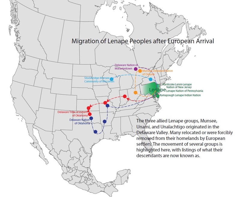
Lenapehoking
Lenapehoking, the homeland of the Lenape for millennia, included parts of present day New York, eastern Pennsylvania, New Jersey, and the Delaware Coast. Further west, the Susquehannock, Shawnee, Erie, and Iroquois peoples also had homelands in what is now Pennsylvania. Everything changed for these Indigenous peoples when the first Europeans arrived.
Contact with Europeans, including the diseases they brought, led to the rapid decimation of Native American populations. European settlers also shifted the dynamics of Indigenous lifeways, driving many to move westward. This forced migration put Indigenous groups at odds with each other both culturally and for basic resources. France, England, and Spain exploited this friction in their attempts to control the New World.
Even though the land of Lenapehoking was already occupied, British authorities offered land ownership to Europeans in order to exploit the rich resources of their North American Empire. By 1683, when William Penn began purchasing land from the Lenape, they were not in a political position to decline.
Pennsylvania’s geography played a major role in shaping America’s history as European settlers expanded west. Surveying land was necessary for the growth and survival of the early colonies, especially after the fraudulent 1737 Walking Purchase added over one million acres to Pennsylvania. The fight over land often became bloody as conflicts arose between Native Americans and the newly arrived European settlers.

The Moravian Church was among the earliest recipients of land acquired through the Walking Purchase. In the early 1740s, Church officials began sending surveyors to survey the land and plot out towns, as well as missionaries to proselytize to the Indigenous peoples. The Moravian contributions to the surveying of Pennsylvania and North Carolina remain important today to historians, researchers, cartographers, and naturalists as they offer some of the earliest documentation of land use in the colonies during tumultuous times of war and unrest.
An estimated 10 million Indigenous peoples lived in North America before the arrival of European colonizers. Many thousands lived in Lenapehoking, the vast homeland of the Lenape, who were the first inhabitants of eastern Pennsylvania and parts of New York, New Jersey, Maryland, and Delaware.
The land that the Moravian Historical Society now occupies is part of the ancient homeland and traditional territory of the Lenape people. We pay respect to Lenape peoples past, present, and future and their continuing presence in the homeland and throughout the Lenape diaspora.
Charter Granted to Penn by the King
On June 24, 1680, William Penn asked King Charles II for a charter for land in America. The only available tract in eastern North America lay west of New Jersey, north of Maryland, and south of New York—an area that England had conquered from the Dutch in 1664 and that the King had given to his brother James, the Duke of York. After discussions, the King granted Penn’s request on March 4, 1681. In return, the Charter required Penn to deliver annually to the King one-fifth of all the gold and silver found and two beaver skins. Although Penn had proprietary authority over the colony, his power was not absolute. The Charter required that his laws be consistent with those of England.
Treaty of Shackamaxon (1682)
"As Long as Water Flows and the Sun Shines and Grass Grows"
Tradition states that the Treaty of Shackamaxon between William Penn and Lenape chief Taminend was good for “as long as water flows and the sun shines and grass grows.” Although this account is fictional, historians do agree that Penn attempted to deal fairly with the Lenape.
Penn intended for Pennsylvania to be a welcoming home for his fellow Quakers. He drafted the “Great Law,” which guaranteed freedom of conscience in the colony. To induce Europeans to settle in Pennsylvania, he offered the incentive of cheap land: “forty shillings per hundred acres.” Settlers arrived from England, Ireland, Wales, Holland, and Germany, some of whom brought enslaved Africans with them.
While their father had attempted to deal fairly with the Lenape, Penn’s heirs, deeply in debt, began a massive land sale. This sale culminated in the fraudulent Walking Purchase of 1737, which added over one million acres of prime land in the upper Delaware and Lehigh River valleys to the Penn’s land grant. The Penn sons were not interested in offering compensation for it.
The Walking Purchase of 1737
John, Richard, and Thomas Penn, along with Provincial Secretary James Logan, presented a deed to the Lenape living in the upper Delaware and Lehigh Valleys. They insisted the document proved that William Penn had purchased the land in 1686. When no proof of sale could be produced, the Penns stated that their father had not paid for the land because a survey had never been completed to the satisfaction of both buyer and seller. This immediately raised suspicion with the Lenape.
The deed indicated that the purchase extended from present-day Wrightstown, northwest into the interior "as far as a Man could walk in a day and half." Unbeknownst to the Lenape, the Penns had hired scouts to clear a path, and the “walkers” were experienced runners.
This fraudulent land claim has become known as the Walking Purchase. Penn’s heirs achieved their goal: they had stolen over one million acres of prime land from the Lenape. However, this event contributed to a later catastrophe as tensions increased between Indigenous peoples and European settlers.
A Chance for Revenge
Forced from their homeland, many Lenape moved west where they joined with other displaced Indigenous groups. Eventually they were pushed further west where the French welcomed them. As the French implemented their claims to the Allegheny and Ohio River valleys during the mid-1750s (French and Indian War 1754-1763), warriors from the Lenape and other displaced tribes moved down the Susquehanna and ravaged Pennsylvania's frontier. The Quaker Party of the provincial legislature charged that the Lenapes’ actions were the direct result of the Walking Purchase.

Tashawaylennahan (c. 1695–1760)
Land Grant to Tunda Tatamy or Tashawaylennahan
1738
John Penn, Thomas Penn, and Richard Penn
Brown manuscript ink, parchment, silk ribbon, resin and paper pendant seal
Land grant, 12 x 27 3⁄4, seal 8 1⁄2 x 6 1⁄2
Collection of the Moravian Historical Society
On April 28, 1738, the three descendents of William Penn—John, Thomas and Richard—granted Chief Tunda Tatamy 315 acres just east of where the town of Stockertown now stands. Tatamy paid 48 pounds, 16 shillings, and sixpence for the property and the rights to settle, build dwellings, farm, forest, or mine. After the walking Purchase of 1737, Tatamy’s grant was again confirmed through the issuance of a second land patent on January 22, 1741.
Tashawaylennahan, “Moses Tunda Tatamy,” and his family were granted permission from the Iroquois Council and the Pennsylvania provincial government to stay in the Lehigh Valley after the results of the Walking Purchase. The Lenape leader was a diplomat, translator, guide, and missionary for the provinces of Pennsylvania and New Jersey.
Although biographical information is scarce and often biased by European views of Indigenous peoples, scholars generally accept that Tashawaylennahan was born in southern New Jersey into the Unami branch of Lenape around 1695. Further research is needed to determine where he learned English, European policy, and politics. Tashawaylennahan moved into the Lehigh Valley in the early 1730s and began farming along the Forks of the Delaware. It is during this time that the historical record begins for this key figure in early Native American and European diplomacy.
Based on documents of the Philadelphia Yearly Meeting Records housed in the Special Collections at Haverford College, we can chronicle Tashawaylennahan’s contributions to negotiating peace during the French and Indian War.
Surveying the New World
Meanwhile, the newly acquired land needed settlers to clear and farm it. Many early maps were reproduced in different ways to entice people in Europe to settle in the New World.
Copy of Special Charte von Pennsylvania
Eugene Leibert
American, 1835-1910
Hand copied reproduction, 17.75 x 19.75
Collection of the Moravian Historical Society, 1857
The original map was created by Ludwig (Lewis) Evans (c. 1700-1756) and written in English. Another version was created in German to encourage immigrants to come to Pennsylvania to settle. Leibert reproduced the German version.

Surveying was a respected skill in colonial society
In Pennsylvania, the authority to produce official surveys rested with the surveyor general. This was an appointed, prestigious, and influential post that included a seat on the Provincial Council. It was the job of the surveyor-general to deputize surveyors, check their work for accuracy, and ensure that no conflicts with existing European settler property claims were present. Native American rights were not recognized.
Pennsylvania surveyors, once deputized, were required to post a bond and take an oath of office as a guarantee of their skill and honesty. Some learned the skill as apprentices, others were taught in European universities before immigrating to the New World, and still others were self-taught. Important sources of information for surveyors included Geodesia: The Whole Art of Surveying and Measuring of Land Made Easy by John Love (1688) and The Practical Surveyor, or the Art of Land Measuring Made Easy by Samuel Wyld (1725). However, these two sources would not have been possible without the work of Edmund Gunter.
Edmund Gunter (1581-1626)
Edmund Gunter was an English clergyman, mathematician, astronomer, and inventor. His interest in geometry led him to develop a method of land surveying using triangulation. Gunter invented many surveying instruments, including the Gunter’s chain (1620), the Gunter’s scale (1623) to assist in numerical calculations, the crossbow quadrant (1623) to determine altitude, and a detailed description of a simplified astrolab known as the Gunter’s quadrant to tell time. All these instruments would be found in a colonial surveyor’s field kit. In addition to the instruments invented by Gunter, surveyors also used a magnetic compass, circumferentor, theodolite, level, and plane table. Drafting instruments such as the protractor, plain and diagonal scales, and the trigonometric table were equally important in completing the survey.
Surveying was a seasonal task. In the field, surveyors often faced unpredictable weather and technical difficulties. The surveyor’s honesty and skill were routinely met with the unethical expectations of their patrons. Colonists demonstrated a willingness to forge survey warrants, offer bribes, or, in extreme circumstances, issue death threats to acquire or protect their land claims.
Tools of the trade


C. 1754
Unknown maker
Brass
Collection of the Moravian Historical Society
This four-quadrant compass was used by early Moravian surveyor George Golkowsky. While we do not know the maker of the compass, we do know that the best surveying equipment came from England. Some early American surveyors made their own. This compass is brass with “For Bethlehem 1754” inscribed on the compass face.

Date unknown
Unknown maker
Collection of the Moravian Historical Society
A spyglass is a hand-held refracting telescope primarily used for terrestrial observation. In October 1608, Dutch instrument maker Jacob Metius applied for the patent application for an optical telescope. In the past 400 years, the shape and function of the instrument has remained the same; only the magnification has become stronger. During their prime, mid-18th until mid-19th century, spyglasses were made of various materials including gold, silver, ivory, and even tortoiseshell. It was a perfect surveying tool because its foldable design made it compact enough to carry anywhere. The user could adjust the length and slide the eyepiece until it was focused.
Four Steps to Acquire Land
European settlers who wanted to own land followed a legal process set up by the provincial government. The four-step process included entry, warrant, survey, and grant.
Entry was the formal act of notifying the government of the desire and reason to acquire land. Once accepted, the government issued a warrant which entitled the claimant to have the potential land surveyed. The survey was a precise, descriptive drawing of the land boundaries. After the surveyor-general reviewed the surveyor’s work for accuracy and signed off on it, a grant (patent) was made by the government. Once the land was purchased, a final deed was issued to the new landowner.
Quite often, people failed to execute all of the steps needed to properly acquire land. Many never bothered with this process at all: they simply took possession of the land as squatters, through false land claims, or by forcibly removing Native peoples from their ancestral homeland.
Town Planning: A Group Endeavor
Beginning in 1734, the prime directive of the Moravian Church was to build Moravian settlements globally in support of Count Zinzendorf's desire to propagate the community's teachings worldwide. From initial concept to actual settlement, Moravian communities were pre-planned by Moravian leaders in Herrnhut, Germany, and approved by Count Zinzendorf.
Although plans of settlements do vary in detail, some common characteristics include a central square, the focal point of the Gemeinhaus and church to the community, and a God’s Acre (cemetery) located just outside the central community.
In 1735, Savannah, Georgia, was chosen as the site for the first Moravian settlement for missionaries to proselytize to the Cherokee and European settlers. This settlement did not last due to the low number of conversions and because of hostilities toward the Moravians by other European inhabitants. By 1740, a group of Moravians moved from Savannah to Nazareth, Pennsylvania.
In December of 1741, Count Zinzendorf arrived in Pennsylvania to visit his congregants, purchase land, and plan out new Moravian towns. It was during this visit that Bethlehem and Nazareth began to become organized into a large-scale group endeavor known as the General Economy. Under the General Economy, all goods, produce, and labor were held in common, and the church owned all land, buildings, and shops. In return, members of the community received housing, food, and care from birth to death. Nazareth and Bethlehem were complementary settlements, with Nazareth supplying the agricultural products and Bethlehem serving the Moravians' industrial needs.
Nazareth
On July 15, 1741, the Moravian church announced that the tract of land now known as Nazareth had been purchased from George Whitefield. This purchase enlarged Moravian land holdings and consisted of the Gray Cottage, the First House, and the partially completed Whitefield House. Maps produced after 1757 show a well-developed settlement. Old Nazareth was laid out as an irregular square, containing a Gemeinhaus, Familienhaus, cow stable, barns, bakery, weaver’s house, washhouse, pigsty, milk house, coal shed, flax house, and smithy (all these structures have disappeared or been renovated beyond recognition). To the north, situated among a large orchard, was the Whitefield House, the First House, and the Gray Cottage. The Manor House was located northwest of the Whitefield House.
New Nazareth was laid out to the west of Old Nazareth in 1771 and was characteristic of the typical European pre-planned town with a central open plaza.
Two streets intersected at a square, and 69 lots were proposed with 44 laid out. Some of the first houses were occupied by carpenter Peter Worbass and hatter Jacob Christ, which were quickly followed by a community store. In 1773, the Single Brothers’ House was erected, as well as houses for nail smith Melchior Christ, baker Wenzel Bernhardt, and harness maker August Schloeser. A flurry of building activity took place between 1780 and 1784 with nine houses completed, ending with the completion of the Single Sisters’ House in 1784. This building activity gave Nazareth a potter, blacksmith, gunsmith, silversmith, shopkeeper, mason, and tanner.
Village Near Nazareth


Lititz
Count Zinzendorf had, in 1742, hoped to have a settlement in Lancaster and was pleased when John George Klein offered part of his property to erect a log church for itinerant Moravian ministers to preach. Klein allowed a Gemeinhaus to be constructed beginning in 1746. By 1749, this Moravian church had a congregation of 35 people.
On February 9, 1757, Lititz was surveyed and laid out in lots by Andreas Hoeger, with a main street running southeast by northwest with 66 lots, in groups of six, with cross alleys between them. At each end of the town two groups of eight lots flanked another cross alley, which led to the Platz (main square). The entire town was to occupy 19 acres except for the God’s Acre. Hoeger may also have planned an earlier vision for Lititz. An undated map shows a slightly different plan than the one that was used in 1757.
Map of Lititz, Pennsylvania
c.1750Unknown
Ink, watercolor, paper
Collection of the Moravian Historical Society
Friedensthal
On October 28, 1749, John Nitschmann and Henry Antes began to search out land to erect a large mill for the purpose of grinding grain into flour. On January 3, 1750, a deed was made out to Henry Antes for 324 acres of land “situated on the branches of Lehietan in the Forks of Delaware in Bucks County.'' Land was cleared and the foundation walls of the mill and farmhouse were begun. The mill was operational by mid-August 1750. The farmhouse was completed in the spring of 1751 and was 32 by 20 feet, two stories high, with four rooms. Additional buildings included a framed barn and three annexes for horses, cows, and sheep.

Schoeneck
In 1754, residents living north of Nazareth petitioned the Moravians for a minister. Franz Clewell’s house was used as the meeting place from 1755 until it became too small for the growing number of congregants. The Nazareth diary states in 1761 that “a piece of land behind Nazareth has been shared out into lots…The beginning of a settlement has been made.” Georg Golkowsky laid out 12 lots, six on either side of the road. George Clauss and his wife Mary Catherine, Jacob Volk and family, and Gottlieb Demuth were the first three married couples to occupy Schoeneck (translated as “Beautiful Corner”) in June 1762.
Schoeneck Land Claims
George W. Golkowsky
German American, 1725-1813
Map, 11.75 x 16.75
Moravian mapmakers
Andrew (Andreas) Hoeger (August 14, 1714-?)
Andrew Hoeger was an architect, surveyor, and master builder from Nuremberg, Bavaria. He arrived in Bethlehem in April 1754. He was employed as a draftsman and superintendent of buildings in Bethlehem. In August 1754, he traveled with Peter Boehler to survey the Moravian Church’s North Carolina property. Returning back to Bethlehem by the end of 1754, Hoeger surveyed, drafted , and planned Lititz and the new Nazareth God’s Acre.
Among Hoeger’s best known maps are Bethlehem Tract with all Adjacent Lands 1755 and his 1754 map of Wachovia Tract in North Carolina. Hoeger produced many architectural drawings, which can be found in the collections of the Moravian Historical Society and the Moravian Archives in Bethlehem, Pennsylvania.
His surviving works attest to his skills in surveying, drafting, building, and town planning. He held positions on numerous Moravian committees and for a decade participated in the growth of the Moravian settlements in Pennsylvania.
Hoeger's final days in Pennsylvania are a mystery.
He left Bethlehem on September 4, 1764, and never returned. A letter was received September 17, 1764, that spoke of his intentions upon leaving Bethlehem.
While this was the last known report of Hoeger in Pennsylvania, Johannes Ettwein had a chance encounter with the wayward Moravian in Charleston. He wrote to Friedrich von Marschall in Bethabara on December 5, 1765. [WachP 149,MAB]
Philip Christian Gottlieb Reuter (September 5, 1717 - December 30, 1777)
Philip Christian Gottlieb Reuter was a surveyor, town planner, and forester from Steinbach, Germany. In 1732, during an apprenticeship in Germany, he discovered that he was naturally gifted at mapmaking and surveying. Three years later, he was appointed royal surveyor of Erbach im Odenwald in what is today central Germany.

Reuter became an active member of the Moravian Church in 1738, after surveying the lands around the Moravian settlement of Herrnhaag. The church sent him to America in 1756 where he worked for two years making surveys, training other surveyors, town planning, and architectural tasks in Pennsylvania.
North Carolina
On July 21, 1758, he traveled to the Moravian settlement of Bethabara, North Carolina, where, for the next 20 years, he performed extensive map and survey work in this largely uncharted region.
Reuter served many roles in Salem. He had oversight of laying out the town, the building of houses, supervising the builders, and paying laborers. In the 1770s, he was appointed Salem’s forest keeper, waterworks manager, and roadmaster.
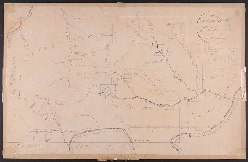
Wachovia Tract, North Carolina
C. 1760
Philip Christian Gottlieb Reuter
German American, 1717-1777
Paper, ink, mounted on cardboard
Map, 16.25 x 10.25
Collection of the Moravian Historical Society
Reuter divided the Wachovia Tract into three parts, which he in turn surveyed separately. This allowed him to combine all three tracts into one large map, The Grundriß, which is nearly 7 feet long. Not only did this grand map show nearly 100,000 acres of Moravian land holdings, but it also detailed the flora and fauna of the area, along with topographical features such as mountains, streams, and paths.
In 1773, Reuter requested and was appointed to a committee to construct the town’s first waterworks. This project was only the second municipal waterworks to be completed in the United States. The first waterworks in America was the Moravian-built system in Bethlehem, Pennsylvania.
The last three years of Reuter’s life were plagued with a debilitating disease that kept him from his work. Reuter died December 30, 1777, in Salem, North Carolina.
While most of his time was spent in North Carolina, his contribution to Pennsylvania surveying is twofold. First, his notes on town planning and his maps are some of the most detailed of the region, and second, he taught noted colonial surveyor Georg Golkowsky the skills of surveying and town planning.
George Wenzel Golkowsky (February 23, 1725- 1813)
Golkowsky was born in Bobrek in Upper Silesia. By the age of five, he had left home to escape religious persecution. He fled to the Moravian settlement of Herrnhut in 1736, where he apprenticed to Andreas Boehner, a cabinetmaker. Although he was scheduled to arrive in America in 1750, he was delayed in London, and in 1752, he was instead instructed to go to Labrador with the missionaries Matthaus Kunz and Friedrich Post. When the missionaries returned to London in 1753, Golkowsky was finally able to sail to the New World, arriving first in New York, and then in Bethlehem on September 21, 1753.
In Bethlehem, Golkowsky was made assistant to Philip Christian Gottlieb Reuter, the cartographer of the community. Working alongside Reuter, Golkowsky learned the skills and techniques he would use later in life. Reuter and Golkowsky were tasked with surveying all the lands belonging to the Bethlehem and Nazareth tracts. Along with surveying, Goklowsky also kept account books of the congregations, taught music, and acted as the warden of Nazareth and Christian’s Spring.
In August 1757, George Golkowsky produced a detailed survey of Christiansbrunn (Christian’s Spring). His survey measured the dimensions of each building, identified the crops that were planted, and sketched the lanes and paths that traversed the community. He also tried, with hash marks, to indicate the topography of the site. Golkowsky’s attention to detail may have been learned from Reuter, who often used descriptive language and hash marks on his maps.
After Reuter left for North Carolina in 1758, Golkowsky became the main surveyor, although Andreas Hoeger was also in Bethlehem. Golkowsky died in Nazareth in 1813, leaving behind many travel journals, notebooks, and ledgers. Most of these are in the collection of the Moravian Archives in Bethlehem, Pennsylvania, and have not been translated into English from their original German.
Gemein Land an der Mahoney
(Translation: Community Land on the Mahony) 1771
George W. Golkowsky
German American, 1725-1813
Ink, watercolor, paper
Map, 13 x 8.5
Collection of the Moravian Historical Society
Colored survey map showing common Moravian land between the Mahoney, two pine trees, and a stone. Also shows an orchard or forest area and roads.
